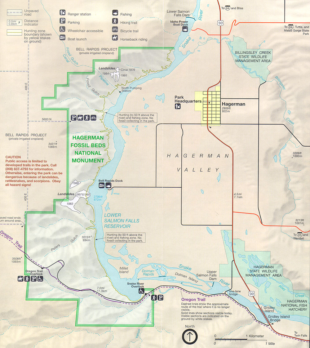
Labels:text | map | atlas | diagram | plan OCR: To (84) and Bliss === Unpaved Lower Salmon road Ranger station Fishing Falls Dam River 0.5ml Distance P indicator Parking Hiking trail Idaho Power 30 0.8km Boat Dock To (84), Tuttle, and Hunting zone Wheelchair accessible Bicycle trail Malad Gorge State boundary (shown Park by yellow stakes on ground) Boat launch Horseback riding Fossil Gulch BELL RAPIDS PROJECT Snake (private irrigated cropland) BILLINGSLEY CREEK Canal STATE WILDLIFE MANAGEMENT AREA Landslides -Circa 1976 1984 Pipeline 1991 Billingsley Fossil ===== Gulch North Pumping Stationy 400 E Park Headquarters Hagerman 2959ft 922m Hunting (to 50 ft above the Creek 5600 N river) and fishing zone. No fossil collecting in the park. BELL RAPIDS PROJECT private irrigated cropland) HAGERMAN 3431 ft FOSSIL BEDS 1069m NATIONAL HAGERMAN 3209 ft CAUTION 1000m Public access is limited to MONUMENT developed trails in the park. Call (208) 837-4793 for information. VALLEY Otherwise, entering the park can be dangerous because of landslides, rattlesnakes, and scorpions. Obey Bell Rapids Dock all hazard signs! 79,00 Landslides 1987&1993 4.5ml 279911 7.1 km 872m 400 E 1983 ======= LOWER aved road ends um around area. SALMON FALLS 3213fr 1001m RESERVOIR Oregon 8 To 84 and 3013ft Hunting (to 50 ft above the Wendell Trail 934 m river) and fishing zone. No fossil collecting in the park. Gulch Peter 3508ft 1093m Snake Millet HAGERMAN Oregon Trail Island Dolman Upper STATE WILDLIFE Overlook Rapids Dolman Island Salmon Falls MANAGEMENT AREA Dam River Snake River 7.0m Overlook 11.3km one-lane & P bridge 30 Creek Oregon Trail HAGERMAN Dashed lines show the approximate route of the trail where it is no longer Gridley NATIONAL FISH visible. Solid lines show sections visible today. Island HATCHERY Visible sections are indicated on the Gridley Island ground by white stakes. Bridge Creek North To 1 Kilometer Twin Falls Yahoo TTO 0 1 Mile